Beachbuoy
Frequently Asked Questions
What is Beachbuoy?
Beachbuoy is our interactive, near real-time web app designed to help you stay informed about any storm overflow releases at nearby bathing waters. We know the importance of transparency when it comes to storm overflows and the environment, so we’re upgrading Beachbuoy and releasing a new version in spring 2024. This new version will not only be easier to use, but will include all inland storm overflows, and have a host of other features created together with our customers and stakeholders.
What are storm overflows?
During heavy rain, local sewer networks can struggle to cope with the amount of water entering pipes and storage tanks. When they fill up, we use pressure relief valves built into the network – known as storm overflows – to stop homes and businesses from flooding.
These overflows release excess water through outfalls into rivers and the sea. Storm overflows are part of the design of the sewers and are regulated by the Environment Agency. They're used in areas where the sewers were built to carry both wastewater from homes and businesses, and rainwater from roofs, gardens and roads.
How do I use Beachbuoy?
Beachbuoy has three features, a map, a historic release table, and this information page.
Each of our region’s designated bathing waters or recreational harbours is represented by a location pin on the map. Simply locate the area you’re interested in on the map and click on the bathing water pin. Beachbuoy will show all the individual outfalls in that bathing water area and information about any recent releases can be found in the pop-up window.
Our Beachbuoy release table allows historic releases to be filtered by bathing site, outfall and type. You can also see our annual storm release data.
How are the releases counted?
Sometimes there may be more than one release from a Storm Overflow within a few hours or days. Releases are grouped together using the 12/24 method. You can read more about this method, as defined by the Environment Agency’s guidance.
This method works like this:
1. When the first release happens, we start counting.
2. Any releases in the first 12 hours count as one.
3. Each release in the next 24 hours counts as one more.
4. Keep counting until there's a whole day (24 hours) with no releases.
5. If there's another release after a day without any, start counting again, starting with one for the first 12 hours, and so on.
How does Beachbuoy know if there has been a storm overflow release?
We use sensors in our storm overflows called Event Duration Monitors or EDMs for short. Data from these sensors is processed through applications to understand if there was a genuine storm overflow release or a false alarm, as well as what time the release occurred and for how long.
Where necessary, manual checks are carried out by our teams of analysts to make sure that the data is as accurate as possible. If we’re looking into a release and its validity, the icon will turn white until we’ve finished investigating, at which point the colour will change to show if there has been a release or not. The data shown on Beachbuoy is the same
data that we share with our official regulators - we believe in open access to data to ensure transparency and accountability for improvements.
How do I know the data is accurate?
The system automatically flags storm releases on Beachbuoy when our alarms and sensors are triggered, before the team can review if it is a genuine event or not. This means we can take a cautious first approach to make the public aware of a potential release at the earliest opportunity. All releases are reviewed and either confirmed as:
Genuine – after review, we can confirm there is/was a release.
Genuine non-impacting – after review, we can confirm there is/was a release, but our tidal modelling determined that it isn’t/didn’t impact the bathing water.
Non-genuine – we’ve reviewed the event and can confirm this was a false alarm, no release happened at this time. False alarms can happen for several reasons including disruption by wildlife, fault to the senor, manual error or power supply issues.
How does Beachbuoy know if the release has affected bathing waters?
Beachbuoy uses something called ‘tidal modelling’ to determine the impact a storm release has on a bathing water. It uses the location of the outfall, the duration of the release and tidal conditions at the time to calculate the changes of impact.
For instance, if the outfall is 5km out to sea, the release was short and the tidal conditions meant there could be no impact on a bathing water, we leave the bathing water pin blue (the outfall icon will however go red). This information is made clear in the bathing water pop-up and details about the release continues to be shown in the Beachbuoy release table.
Can I get notified of releases?
Yes, simply click on the pin of the bathing water location you’re interested in, click ‘sign up for updates’ and enter your details. We will notify you via email if there has been a storm overflow release at the site.
Why can’t Southern Water tell me if the water is safe to swim in?
Storm overflows can have an impact on water quality, however there are many other contributing factors including agricultural run-off, seabird and animal matter and marine activity.
Because of these other factors, Southern Water can’t advise about water quality and whether it’s safe to swim. We can only make predictions about water quality impact caused by storm overflow releases.
How are you making sure Beachbuoy remains useful?
We want to make sure that Beachbuoy provides transparent data, giving the information the public wants in a clear and meaningful way, so we actively listen and seek feedback from our Beachbuoy Working Group. This group is made up of local authorities, campaign groups, bathing water users and interested stakeholders, who advise us on improvements we need to make to Beachbuoy. Changes to the site are presented to the group for feedback, before changes are made.
We also survey Beachbuoy users and hold independent reviews to understand what users would like to see and how they wish to use Beachbuoy. This has been an important part of the process to develop the new and improved Beachbuoy due to be launched in Spring 2024.
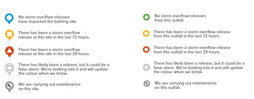
What do the different map symbols mean?
Map symbols: