Problem characterisation – Cuckmere and Pevensey Levels
The Problem Characterisation stage of the DWMP uses the results from the Baseline Risk and Vulnerability Assessment (BRAVA) to explore the causes of risks and the primary drivers. A technical summary provides information on our approach to the problem characterisation.
Current risks in the Cuckmere and Pevensey Levels Catchment
The graph below illustrates the combined results of the 2020 BRAVA assessment for all 18 wastewater systems in the Cuckmere and Pevensey Levels river basin catchment. It shows how many wastewater systems have a risk under each of the 14 planning objectives. For example, for the risk of internal flooding, 12 wastewater systems are in band 0 (not significant), 4 are in band 1 (moderately significant), there are no systems in band 2 (very significant) and 2 were ‘not flagged’ for inclusion (i.e. screened out at the risk based catchment screening stage of the DWMP).

The graph illustrates that storm overflows are the main concern in this river basin based on the BRAVA results for 2020. This is illustrated by the brown bars being the highest for planning objective 6. Pollution, sewer collapse and annualised flood risk were the next most significant concerns.
The wastewater systems with the highest number of planning objectives in band 2 (very significant) are Eastbourne and Hailsham North with 5 objectives in band 2. Bexhill and Hastings has 4 band 2 risks, and Hailsham South and Vines Cross both have 3 planning objectives in band 2. All other catchments have fewer risks.
The specific risks and the causes of risk for each of the wastewater systems are explained in the summary of the problem characterisation for each system. These are available to download from the link next to the name of each system in the table below.
Future risks in the Cuckmere and Pevensey Levels Catchment
The 2050 BRAVA results help us to identify the future challenges for drainage and wastewater management in the Cuckmere and Pevensey Levels river basin catchment. These are:
(a) Growth
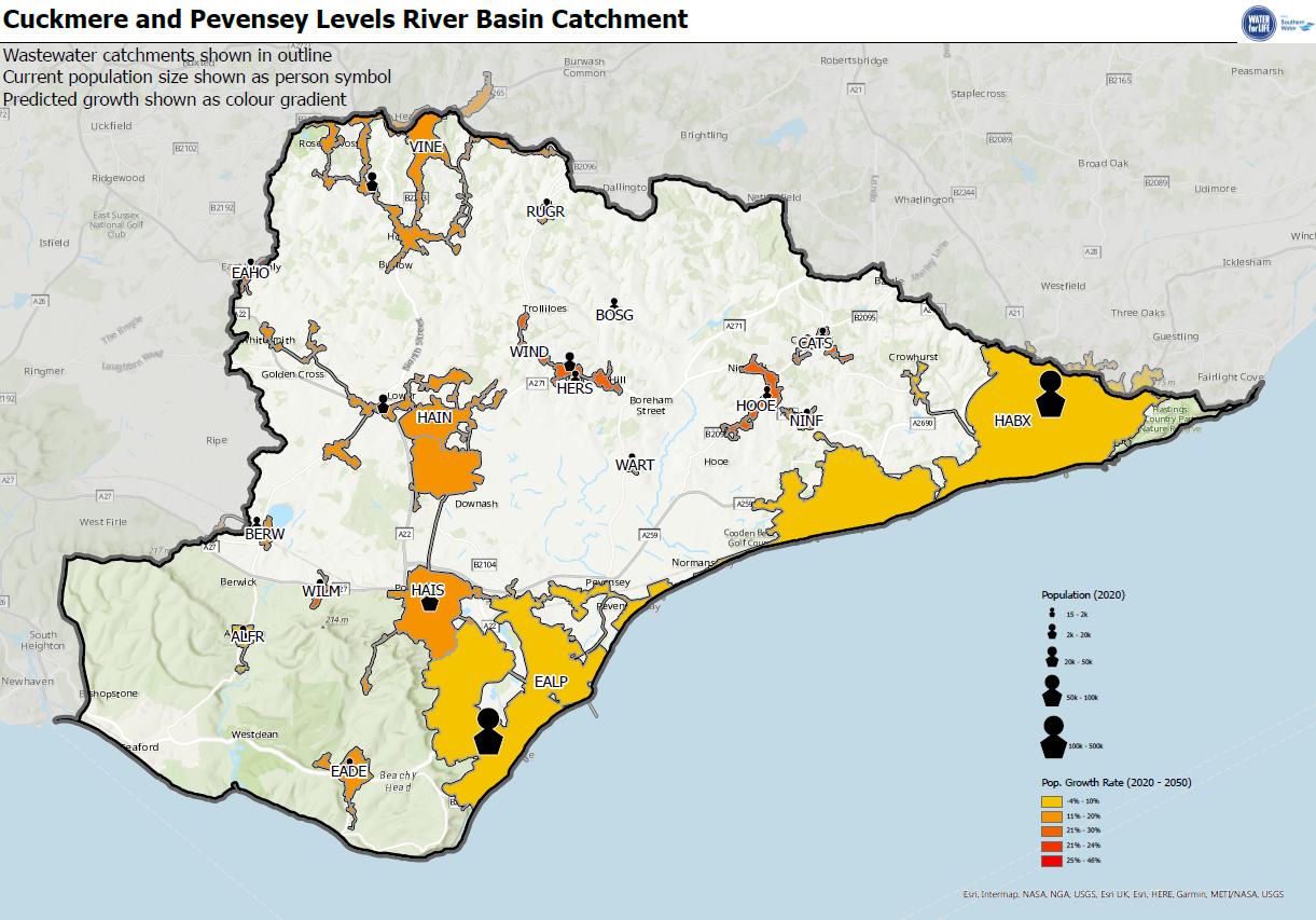
There are several wastewater catchments where new homes, businesses, roads and other infrastructure is planned. The main areas identified for potential new development in the Cuckmere and Pevensey Levels catchment are:
- Eastbourne
- Bexhill and Hastings
- Hailsham North
- Hailsham South
The BRAVA results show that the additional homes and businesses will increase the risks of non-compliance with our Dry Weather Flow (DWF) permits from the Environment Agency in 6 of the 18 wastewater systems, including Bexhill and Hastings, Eastbourne, Hailsham South, Hailsham North, Windmill Hill Herstmonceux and Alfriston. This means further investment will be needed in the future to increase the capacity of our treatment works to accommodate the new homes and businesses.
The additional development may mean that our current permits for wastewater treatment quality might be exceeded by 2050 without further investment in 3 wastewater systems, Windmill Hill Herstmonceux, Hooe and Catsfield.
New development in the Cuckmere and Pevensey Levels catchment might put additional pressure on internationally designated habitat sites such as Pevensey Levels and Hastings Cliffs, so solutions will need to be found to ensure that development is nutrient neutral.
A map of the Stour catchment showing the estimated future growth in each wastewater system is shown below. The technical summary explains how we have considered population growth and urban creep in our DWMP.

(b) Climate change
Climate change will bring greater variability of our weather with warmer wetter winters and hotter drier summers. The impacts we will see will be more intense summer storms that exceed the capacity of the drainage and wastewater networks and cause localised flooding. Hence, the risk of flooding from sewer systems is increasing due to climate change. The technical summary explains how we have considered climate change in our DWMP.
We will work with partner organisations, such as East Sussex County Council and the Environment Agency, who have responsibility for flooding and drainage to consider options and develop opportunities to find solutions that reduce the risks from flooding.
We will need to adapt our wastewater systems to operate in future climates. There will be an increasing need to slow the flow entering our sewer networks so the systems can carry the water without flooding homes and businesses and/or without causing discharges from storm overflows. Preventing additional rainfall entering foul sewer networks, including combined sewer networks where possible, could delay the need to upgrade and enlarge the vast underground network of sewers.
Climate change is expected to have an impact on the risk of flooding in several wastewater systems, especially Eastbourne, Hailsham South, Hailsham North and Windmill Hill Herstmonceux where there is already a very significant risk from rainfall related flooding. The flooding risk will increase by 2050 unless measures are taken to manage and reduce these risks. The BRAVA results indicate that the risk of storm overflow discharges for 5 wastewater systems in this river basin catchment is likely to increase to very significant by 2050.
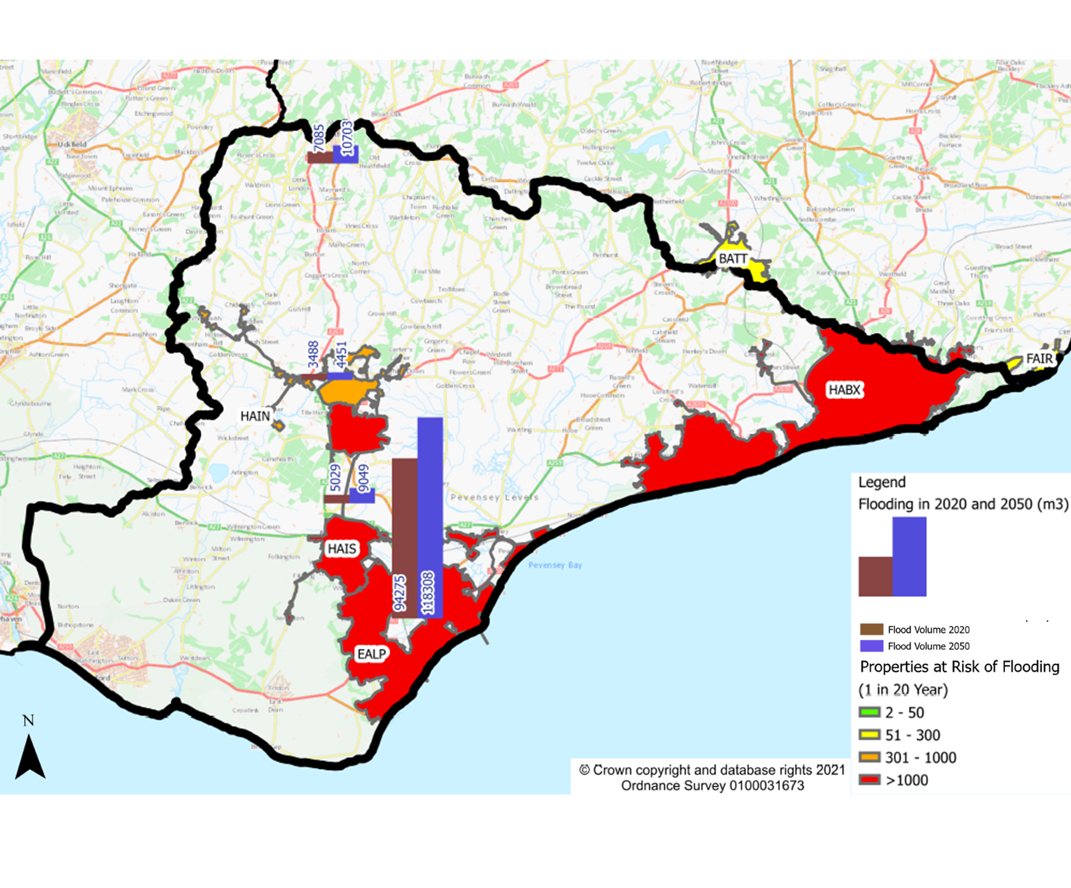
The map below shows the potential impact of climate change, urban creep and growth on the risk of flooding in a 1 in 20 year storm for the wastewater systems. We followed Water UK’s capacity assessment framework to apply a 20% uplift to rainfall forecasts to assess the potential increases in flood volumes shown on the map. Urban creep was estimated using the approach developed by the UK Water Industry Research (UKWIR) report on Urban Creep in sewerage systems (2010).
The map highlights that we will need to adapt to climate change. Adaptation will mean considering long-term sustainable options, such as reducing the volume of rain water entering the sewer network. This approach may provide the capacity within the wastewater system to allow for future growth and therefore reduce both the need for significant increases in the capacity of the existing wastewater systems and reduce discharges from storm overflows.
Investment planning for each wastewater system
We used the BRAVA results and our understanding of the causes of risks and drivers to propose an investment strategy for each of the wastewater systems. Find out more information on how we determined the investment strategies. The strategies help us to target the wastewater systems that need further investment to reduce the potential risks to customers and the environment. We have produced a table that lists the proposed investment strategy for each catchment.
We used a risk based approach to identify the wastewater systems that we need to progress in this first round of DWMPs. For these systems we will develop an investment plan. Our technical summary sets out how we have selected the systems to take forward.
The table below lists the wastewater systems in the Cuckmere and Pevensey Levels river basin catchment that we’re progressing further during this first round of the DWMPs into the investment planning stage. We have included a catchment map and an explanation of the causes of risks for these systems (see links in the table below).
The maps and causes of risks for the remaining wastewater systems in the Cuckmere and Pevensey Levels will be published when available.
| System Ref | Wastewater system | Wastewater system map | Information on causes of risks |
|---|---|---|---|
| EALP | Eastbourne | Eastbourne Map | Eastbourne Causes of Risks |
| HABX | Bexhill and Hastings | Bexhill and Hastings Map | Bexhill and Hastings Causes of Risks |
| HAIN | Hailsham North | Hailsham North Map | Hailsham North Causes of Risks |
| HAIS | Hailsham South | Hailsham South Map | Hailsham South Causes of Risks |
| VINE | Vines Cross | Vines Cross Map | Vines Cross Causes of Risks |